Lake Ashmere of Hinsdale, Massachusetts
Lake Ashmere History
During the early 1870’s, Hinsdale and Dalton mill owners were in search of a more reliable water source to power their mills along the East Branch of the Housatonic River. An association was formed for the purpose of creating a water storage reservoir. Land was purchased along “Miry Brook” and the Tracy Brothers were hired as the contractor. In 1872, after two years of work using horse drawn dump carts, an earthen dam was completed, forming a 365 acre lake. The earthen embankment dam is at the south end of the lake and extends 1,525 feet long by 32 feet high. In 1979 the dam and lake became the property of the state of Massachusetts, which still controls the lake today. The lake has a maximum depth of 23 feet and an average depth of eight feet and is divided into two basins by route 143. Lake Ashmere's elevation is approximately 1585 feet making it one of the highest elevation lakes in the state of Massachusetts. Only Buckley Dunton Reservoir is higher at 1762 feet.
According to local legend, the name Ashmere was chosen by William Cullen Bryant, during one of his many trips from the Hinsdale train station to his summer home in nearby Cummington.

The Ashmere Lake Hotel, Hinsdale, Massachusetts
Town of Hinsdale -
Its early history saw farms and saw mills as the primary sources of occupation. In the late 1800s, textile mills flourished, and the community found itself able to install a reservoir and public water an sewer systems. In the early 1900s, the mills departed, and the railroad became the main industry. By the mid-1900s, this industry departed, as well.
Town of Hinsdale -
- Town Hall: 95 Maple St.
- Phone: (413) 655-2245
- Population: 1,872
- Settled/Incorporated: 1763/1804
- Named for: Rev. Theodore Hinsdale
- Elevation: 1,431
Its early history saw farms and saw mills as the primary sources of occupation. In the late 1800s, textile mills flourished, and the community found itself able to install a reservoir and public water an sewer systems. In the early 1900s, the mills departed, and the railroad became the main industry. By the mid-1900s, this industry departed, as well.
Children's Camps
There are three camps along the shores of Lake Ashmere. One is along the north basin and two south of Route 143. They include a coed religious camp, private girls camp and sports camp.
There are three camps along the shores of Lake Ashmere. One is along the north basin and two south of Route 143. They include a coed religious camp, private girls camp and sports camp.
Ashmere Lake State Park
This Massachusetts State Park lies along the southernmost shore of Lake Ashmere and offers a public boat launch and acres of woods that can be accessed from Smith Road.
The public boat ramp is at Ashmere Lake off Smith Road Hinsdale, MA Phone: 617-727-1843 - for the Office of Fishing and Boating Access located in Brighton, MA.
Fisherman access: Small concrete ramp, concrete pad ramp system or gravel ramp designed for smaller boats and parking for boat trailers. Fish species: Smallmouth bass, pickerel, black crappie. Managed by state Department of Conservation and Recreation.
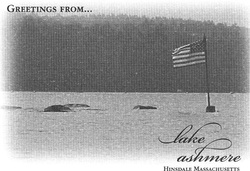
The American Flag can be seen waving proudly from a rock outcropping in the southern basin of Lake Ashmere.
Kayaking on Lake Ashmere (with photos)
For a firsthand account of kayaking along the interesting and picturesque shoreline of Ashmere, please visit Dan and Sheree's website.
For a firsthand account of kayaking along the interesting and picturesque shoreline of Ashmere, please visit Dan and Sheree's website.
Click for Big Ash Bass and Fishing
or
To Top of Lake Ashmere Page
Website designed and published by Creative Dezinz of New England
